IDGenWeb Resource Library
IDAHO MAPS SERIES:
A Historical View Through the Eyes of the U.S. Census
Idaho Maps offers historical and pictorial perspectives of its rich Idaho’s past. This section is a peripheral look through the U.S. Census, and what took place during that decadal era.
U.S. Census, 1850
.gif)
Original Census Map Created by Elaine Johnson © 1998
.gif)
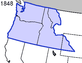
In the U.S. Census of 1850, Oregon Territory had already been incorporated into the United States two years before on August 14, 1848. It was in the year 1846 that brought this land to actuality with the Oregon Treaty of 1846 to which its decisiveness was settled over where the final borderline shall be placed between United States and Great Britain. That was the 49th parallel line nonetheless, yet without regards to the continuing of population from around the around world. The Oregon
Territory became the “new” West to settle into for the perusing years to come. This territory was consisting of the following present-day Washington, Oregon, Idaho, and the westernmost parts of Montana and Wyoming. Here's an article from the New York Daily Tribune in April 1846, about the new land settlement of Oregon.
Oregon Controversy Settled.
U.S. Congress Ratification, June 18, 1846
.jpg)
.jpg)
Prior to Idaho disengagement from the Oregon Territory, Washington Territory became incorporated by March 2, 1853, and during that ensuing period the territorial legislature established several of Idaho’s first counties that will be discuss further on the next page. At first, the original boundaries extended straight over the panhandle of Idaho and portion of Montana. Then other Washington territorial censuses to establish new borders. On February 14, 1859, Oregon became the 33rd State to join the Union, which left Idaho’s entire western bordering into half of Montana and Wyoming to Washington Territory. View the link below that shows how the Oregon Territory looks in lateral to the present-day States.
Additional Reading:
Google Books: The Oregon Territory: A Geographical and Physical Account of That Country and Its Inhabitants (1846) Rev. C. G. Nicolay.
Original Works © Elaine Johnson 1996-1998 Historical Works © Matthew D. Friend 2017